Pages

Wednesday, September 12, 2012

Bay tour on memorial day

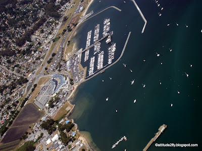
Went out for a bay tour with some friends on a C172....wonderful day....little bumpy at places.....and clouds here and there over the bay....our trip took us from RHV, SJC, Moffet, SFO to downtown SFO, bay bridge, golden gate and return via half moon bay....wonderful trip....had to jump over the clouds few times.....overall nice....
pretty busy for the day....many aircraft in the air, it took time to get a flight following from NORCAL and clearance for Class C and Class B

@3500 ft

Mid field San Jose Airport


I-280 on the left

SFO airport runway 29L (United 747 taking off)

United 747 passed below at 2000 ft

SFO International airport


SFO Downtown with Alcatraz

SFO Piers

Another view of downtown with Alcatraz

South SFO

half moon bay


Coastline


Golden Gate in sight

Half moon bay with coastline


Friday, May 11, 2012

My scary emergency moments and how I dealt with it

Okay friends....lets accept it, flying is fun but brings in lots of challenges & risk as well.....lot of things can go wrong.....however that's what training is all about.....
During my training I got my share of 'oops' moment......and today I would share that with you and the action I took. We all know what needs to be done as taught in our training, but I wanted to share my thoughts about it. Though no one of them resulted in any incident or accident, but did taught me a valuable lessons....hopefully it will teach you something as well....I do wish that you don't encounter any of this situation.....ever

  • Carburetor ice (carb ice) -- It happened in the chilly month of December, I was flying with my instructor and we were going to KKIC from KRHV for a cross country tour in C152 (we were in touch with NORCAL). I was working on my private. The weather in CA during that month is cold (though not as cold as east coast but its cold). We were cruising at 6500 MSL with 2200rpm.  The outside temperature was around 1 degree Celsius. Around Salinas suddenly we noticed a drop in RPM by about 200 rpm i.e. to 2000 rpm. I felt & heard it immediately, however it stabilized at 2000rpm. Since till this point I had just read about carb ice and never actually encountered it. I told my instructor who was busy in his mobile. And he immediately suggested to put full throttle and mixture & also turn on the carb heat. Then while carb heat did its job he said climb higher, just in case we loose engine, the cushion of altitude will give us some chance to plan. I did question him that since climbing higher meaning lower temp and increasing the carb ice issue. But he said its a trade off...since the carb heat is doing its job, you expect to get some relief but in case it doesn't then you have the luxury of altitude to plan your descent. Other action we took was instead of proceeding ahead we started circling above salinas just in case we need to land. Norcal noticed that and gave us a call. We informed them of the situation and told them that so far we are taking precautionary steps. Slowly the rpm started climbing up & returned normal and we decided not to proceed ahead as we knew that temperature over KIC was even low, so chances are still there. anyway long story short, we informed norcal about our decision to head back. Kept the carb heat partially on for a while and returned safely. Lessons learned: Anticipate carb ice in cold conditions. Keep an eye & ear on the engine and take action immediately by putting full throttle, mixture and carb heat. After that try to gain altitude if possible. Couple of days later I went solo and returned without any issues...Happy flying....
  • Son of a gun, its a plane -- Well this was exactly what my instructor said when some daredevil aerobatic aircraft zoomed passed us. This happened when we were practicing steep turn in a C152 before my checkride near KCVH - Hollister. I always had issues with steep turn but on this occasion I was doing good. In between half 3/4 th of the turn on left side I suddenly see an aircraft zooming past from right to left by about 100ft or less. My instructor also saw it and said "son of a gun, its a plane" Immediately I stopped the steep turn and gently pointed my nose down to descend. However we could not catch any glimpse of the tail number or type of aircraft but my instructor thought it appeared as an aerobatic aircraft. Jeez, that was scary......anyway we were done and my instructor was happy with whatever steep turn I had done we returned. Lessons learned: Well scanning before performing any maneuvers is very important. However if a daredevil is hell bent, I don't think you can do much more than just swear. have a safe flight......
  • Low voltage in Battery -- This happened in the month of June when I was flying with my instructor in C172 for instrument rating. Our flight was take off from KRHV, make VOR-A approach to Oakdale, GPS approach into Tracy and then ILS into livermore. The approach to Oakdale was successful and I landed. Immediately put full throttle, flaps up and started our takeoff. However as soon as were airborne, I noticed the electrical red light coming up on the low voltage indicator with battery showing towards a -ve side. This was an indication of low battery voltage or in other words the battery is not charging or discharging. Since our engine was running fine and as the alternator, it was okay. The idea was that after takeoff we will follow the missed approach route from oakdale and then contact norcal and ask them to vector us for GPS tracy. Once I informed my instructor, he suggested that lets troubleshoot that problem before we decide to make another approach. We continued to circle the fields next to oakdale to troubleshoot. Initially switch on/off the battery to see if that helps. No it didn't. Then we took the bold move of switching off both alternator and battery (which means the radios will be off). But that also didn't help. At this point we decided to return back to Reid hill view without making further approaches and get it checked. We informed Norcal about our intention and explained the problem. They asked if we needed help and we politely declined. Since engine was running and as the  instruments it was okay. On the way back, my instructor pulled out the POH and started looking at emergency procedures. Well it pretty much had the same process of turning on/off. While on the way we decided to conserve the battery. So we informed Norcal that we will go radio blind i.e. will switch off radio and other non essential equipment like GPS (as we knew the valley well to navigate) till we are close to the airport. Norcal suggested that its fine and they will let reid hill know about our situation. And then there was silence for about 30 minutes or so. Till we came close to the mission peak mountain. At that point we switched on the radio and informed norcal. The low voltage was still on. Contacted KRHV, since they knew about the situation, they asked if we need help. We said no and requested landing. Landing was smooth, no incident in putting the flaps down. Thanked KRHV for the help and went straight to the hanger and squawed it. Lessons learned: Keep scanning your instruments for any error. If I had been alone maybe I would have landed in nearby airport and requested help. Since I had my instructor along with me, it was good and I could use his help to troubleshoot.

Monday, April 9, 2012

Why is temperature dewpoint important

As a pilot you are responsible for planning and acquiring all information related to the trip. One of the critical information you need to be aware of is temperature dewpoint spread. Let's discuss it in detail:


What is temperature dewpoint -- Simply put it nothing but a temperature, at which the moisture i.e. water vapor in air (or humidity in a volume of air) condenses and appears as liquid, in other words forms cloud. So this parcel of air will need to be cooled to this temperature to form a cloud.
Hence when you gather weather reports, you not only need to know the current prevailing temperature at the airport but also temperature dew point.


The difference between temperature and dew point is known as "temperature dew point spread".


Why we need this information -- This will help pilot get an idea of where the cloud bases are i.e. how high the clouds are possible. Also gives an idea of the likelihood of carburetor ice.


Let's take an example:
Say the temperature at the surface of airport = 14° celsius. 
Temperature dewpoint = 5° celsius


Over here what are trying to find out at what altitude is this temperature available so that any water in the air will condense will form cloud.


The formula to be used:
Cloud base in feet = [(temperature in °F  - dew point in °F) * 1000]
                                                          4.4


hence putting the numbers above:
cloud base in feet = [(57.2 - 41) * 1000)/4.4 = 3681 feet above the surface of airport (add airport elevation to get MSL figures).

What does it mean, if there is enough humidity or moisture in air then expect clouds to form at that that height. This is considering a standard lapse rate. However you should look out for an altitude where this temperature i.e. 5°C is prevailing and will give an idea of cloud base. 
Couple of things it helps us identify:
  1. The ceiling at the airport i.e. if you are planning a flight and need to know how high the clouds are.
  2. carburetor ice, so expect to have the possibility of carb ice at that altitude and above. Keep an eye on RPM to see a drop.
Hope this explanation helped.

Thursday, March 15, 2012

Why most commercial aircraft do not fly supersonic?

Why doesn't general commercial aircraft like boeing 747, 737, airbus 320, 380 etc, travel faster than speed of sound i.e. supersonic. They usually travel at 0.87 mach (1 mach = speed of sound). Concorde was the only supersonic commercial aircraft.
Let's explore the physics of it.
credit - http://theboard.byu.edu
From your knowledge of aerodynamics and aerofoil, you know that the upper surface of the wing is curved and lower surface is not. Hence over upper surface the air flows faster as compared to lower (see image above).
Now as aircraft accelerates and nears the supersonic speed, over the upper surface of the wing the airflow (or for that matter any curved surface including canopy, nose etc) can potentially be at supersonic speed. Now at this point a shock wave generates a the point where the supersonic airflow slows down to subsonic. As you can see from the image below, at M=0.77, at the middle, the airflow before it is supersonic and beyond that is subsonic. This results in a shock wave. The airspeed where this shock wave starts appearing is called critical mach number
credit - wikipedia
This shock wave requires energy and that is supplied by the aircraft itself in form of additional thrust, which means the additional thrust is required to keep the aircraft moving ahead and to compensate the loss of thrust due to shock wave. This acts as a drag and is referred to as wave drag. The engine thrust may not be enough to overcome this drag and move even faster
Other aspect is that the supersonic speed can cause structural damage.
These two reasons explains why general commercial aircraft does not fly at supersonic speed. 
Concorde was able to overcome these 2 design issues and fly supersonic.
Hopefully future air travel will be faster.

Monday, March 12, 2012

Friday, March 9, 2012

Communication in Class B and C

Communication is very critical while flying but your responsibility increases when you are in the vicinity of Class B or C airspace in US. Let me put some do's and don't about communicating with controller in these airspace. 
Read about the airspaces here.


Class B:
  • Typically large airports (in terms of traffic) are classified as Class B (bravo) e.g. San Francisco, Los Angeles, Washington etc.
  • Shape of class B appears as upside down wedding cake. Refer the image below.
Credit - Wikipedia
  • Requirements to fly in Class B are list here: Requirements (pilot certification, equipment etc.)
  • Communication procedure - You have to be cleared to enter into Class B before you enter the airspace. Most likely you would have to speak with an area controller before you can enter the airspace and may not be directly with the ATC tower of that airport. You should communicate atleast 10 nm in advance. Sample communication with Class B controller
Aircraft Calling: Norcal, Cessna 1234MA at 3500ft over livermore airport, would like to transition through Class B for a bay tour. - Using the standard phraseology of who,where & what. Assuming you are flying through a class C.

Norcal: Aircraft calling standby. -- This means that they have just acknowledged your presence but no permission has been granted yet. KEEP OUT OF AIRSPACE,  may have to circle around.

Norcal: Aircraft calling, say your request.

Aircraft Calling: Norcal, Cessna 1234MA at 3500ft over livermore airport, would like to transition through Class B for a bay tour. - Repeat your request.

Norcal: Cessna 1234MA, CLEARED INTO CLASS Bmaintain 3000ft, squawk 1510. -- one marked in red is the golden tagline or "magic word" you need to hear from the controller. Without which you are not supposed to enter that airspace. If you do, its a violation and you may end up loosing your license.


Norcal (Alternate): Cessna 1234MA, remain clear of class B airspace -- STAY OUT of airspace.

Important points:
  • Even if ATC does not use the exact words (may use it differently or forget about it), its your duty to confirm that as its your license which is in line of fire. Ask ATC.
  • If ATC gives a vector (e.g. turn right heading 130) which may result in a flight path into class B, its your responsibility to be aware of it and ask ATC if you are cleared into Class B. Better ask then be sorry.
Class C:
  • Typically medium size airports (in terms of traffic) are classified as Class C (Charlie) e.g. San Jose etc.
  • Shape of class C is cylindrical with an outer shell. 
  • Requirements to fly in Class C are list here: Requirements (pilot certification, equipment - transponder, comm etc).
  • Communication procedure - You have to establish 2 way radio communication to enter into Class C before you enter the airspace. Most likely you would have to speak with an area controller before you can enter the airspace and may not be directly with the ATC tower of that airport. You should communicate atleast 10 nm in advance. Sample communication with Class C controller
Aircraft Calling: Norcal, Cessna 1234MA at 3500ft over livermore airport, would like to transition through Class C for a bay tour. - Using the standard phraseology of who,where & what. Assuming you are flying through a class C.

Norcal: Aircraft calling standby. -- This means that they have just acknowledged your presence but no permission has been granted yet. KEEP OUT OF AIRSPACE,  may have to circle around.

Norcal: Aircraft calling, say your request.

Aircraft Calling: Norcal, Cessna 1234MA at 3500ft over livermore airport, would like to transition through Class C for a bay tour. - Repeat your request.

Norcal: Cessna 1234MA, CLEARED INTO CLASS Cmaintain 3000ft, squawk 1510. 


Norcal (Alternate communication): Cessna 1234MA, standby - If the controller speaks up your aircraft tail number then also you are cleared into the airspace as that is establishing a 2 way radio communication.

Important points:
  • If ATC gives a vector (e.g. turn right heading 130) which may result in a flight path into class C, its your responsibility to be aware of it and ask ATC if you are cleared into Class C. Better ask then be sorry.

Thursday, March 8, 2012

Flying to a uncontrolled airport

Once you get your wings, it opens up the world for you. Your travel will take you to different types of airports e.g. controlled, uncontrolled, military (maybe) etc.
In this post I would like to touch upon a plan, communication and any other important aspects around flying to an uncontrolled airport. For this I will take you for a VFR flight from my home airport of KRHV (Reid Hill view airport) to KCVH (Hollister). 


Step 1 - Prepare a flight plan
  1. Get weather from adds.aviationweather.gov or any other aviation weather websites. Most important step for VFR flight. Links on my blog.
  2. Pull your sectional chart and identify the start and destination and mark with pen. 
  3. identify checkpoints preferably  every 10 nm. The checkpoints should be clearly visible from your altitude e.g. large warehouse, road intersection, water body etc. Identifying checkpoints close enough will help you correct your flight path sooner if you deviate. You can also use VOR, DME if you have the equipment.
  4. Do time, distance & fuel calculation, based on the altitude you are flying. Altitude will be decided by the magnetic course if you plan to fly above 3000 ft e.g. 0-179 degree, odd + 500 ft MSL (3500,5500); 180-359, even + 500 ft MSL (4500, 6500). Refer FAR 91.159 . In this flight plan its 130 degrees and hence odd + 500 ft.
  5. Do weight and balance and ensure you are within the CG limits of the aircraft you are using.
  6. Identify in your flight plan, TOC (top of climb) & BOD (beginning of descent).
  7. Once you have the flight plan ready, make a final call to get weather briefing and if required file VFR flight plan by calling FSS on  1-800-WXBRIEF. Important points to obtain are, route of flight, weather at destination, return flight weather etc. You should also obtain any flight restrictions like TFR, NOTAMS (runway closure) etc.
  8. Check AFD for details of KCVH e.g. frequencies of ASOS/CTAF, runways available, runway length, runway lighting, fuel stations etc.
  9. Usually in my flight plan I draw the runways and the my expected flight direction. This gives me the picture of how I will make an entry.
  10. Now you are all set for the travel. Start your engines and contact ATC and take permission to take off. Bon Voyage
See this image below for some help.
credits - skyvector.com
Step 2: Enroute (assuming no flight following)
  1. Communication is the key word. Giving your position reports regularly is very important in VFR flight. In the above plan, after taking off from RHV, you should tune   in to the next nearest airport e.g. South County and give position reports. 

  • Position call 10 nm ahead
  • Position call 5 nm ahead
  • Position call abeam

  1. Keep scanning for traffic. Use standard scanning techniques.
  2. Get ASOS/ATIS/AWOS information of airports enroute if available.
Step 3: Descend and Land
  1. Get ASOS/ATIS/AWOS information of destination airport if available atleast 10nm ahead. This will help you visualize the weather condition and if appropriate for VFR landing and also the winds will give you a clue of the runway to land.
  2. Start descending based on your flight plan to the destination airport.
  3. Descend till 1000 ft above traffic pattern when approx 1nm away e.g. if pattern altitude is 1500ft then descend to 2500ft. This is required so that you can identify the windsock and general direction of wind. Will help you to determine the runway to land
  4. Once you have identified the runway to land (by checking the windsock or as advised by any other aircraft in the pattern), then you should plan to enter the traffic pattern. Remember you are at 1000ft above TPA. As per FAR you should use the 45 degree entry procedure. See image below.
  5. Make 45 degree entry into the downwind leg after descending to TPA. You should give position report for 45 degree entry, downwind, base, final and after clearing the active runway.
  6. Voila you have successfully made it to the airport. 
  7. Now taxi to the terminal, fuel up, freshen up, and prepare your flight plan for the return.
  8. Don't forget to close flight plan if you have opened any with FSS.

credit - wikipedia 


Sample position report calls. Format is "Airport name traffic; Who; Where; What; airport name". This is suggested only and can be tweaked as required. Idea is to communicate and give as much information as possible so that other aircraft in the vicinity can visualize your position. This is called situational awareness.
  1. Position report to South County @ 10nm -- " South County traffic; Cessna 1234MA; Is at 3500 ft, 10 nm North of the airport;Will be overflying abeam the airport for hollister; South County" -- North with respect to the airport and your aircraft. You will have to visualize your position. You can cross check with your heading indicator i.e. if the tail of the heading indicator is pointing to 180 then you are north of the airport heading south. Use N=0,E=90, S=180,W=270.
  2. Position report to South County @ 5nm -- " South County traffic; Cessna 1234MA; Is at 3500 ft, 5 nm North of the airport;Will be overflying abeam the airport for hollister; South County"
  3. Position report to South County @ abeam --  " South County traffic; Cessna 1234MA; Is at 3500 ft, abeam the airport;for hollister; South County"
  4. Call 1 - 10nm away -- "Hollister traffic; Cessna 1234MA; Is 3500 ft, 10 nm North of the airport;Inbound for landing, any other traffic please advise; Hollister" -- Idea is to get traffic pattern or any other useful info from other aircraft.
  5. Call 2 - 5nm away -- "Hollister traffic; Cessna 1234MA; Is 2500 ft, 5 nm North of the airport;Inbound for landing, any other traffic please advise; Hollister"
  6. Call 3 - 1nm away -- "Hollister traffic; Cessna 1234MA; Is 2500 ft, 1 nm North of the airport;Will be circling above the airport to check wind direction. Any other traffic please advise; Hollister".
  7. Call 4 - Circling -- "Hollister traffic; Cessna 1234MA; Is 2500 ft, above the airport;Will be circling  to check wind direction. Any other traffic please advise; Hollister".
  8. Call 5 - 45* entry-- "Hollister traffic; Cessna 1234MA; Is at 1500 ft; Inbound 45degree for downwind on runway 32; Hollister".
  9. Call 6 - downwind entry-- "Hollister traffic; Cessna 1234MA; Is downwind; Inbound for landing on runway 32; Hollister".
  10. Call 7 - base entry-- "Hollister traffic; Cessna 1234MA; Is base; Inbound for landing on runway 32; Hollister".
  11. Call 8 - final entry-- "Hollister traffic; Cessna 1234MA; Is at final; Inbound for landing on runway 32; Hollister".
  12. Call 9 - After landing and clearing the runway -- "Hollister traffic; Cessna 1234MA; clear of the active runway 32; Hollister".
  13. Call 10 - hold short and Taking off -- "Hollister traffic; Cessna 1234MA; is holding short of active runway 32; Will be a straight out departure to north;Hollister".
  14. Call 11 - upwind -- "Hollister traffic; Cessna 1234MA; is upwind from runway 32; Will be a straight out departure to north; Hollister".
Comments appreciated from viewers so that I can enhance this post and correct for any mistakes.

Monday, March 5, 2012

Why aircraft's fly at high altitude

Reasons:

  1. Terrain clearance - As the land is not flat and has obstructions (man made or natural), to keep it clear of them aircraft need to fly high
  2. Less Air resistance - Since air is thin at higher altitude, the resistance is less and it can travel efficiently and faster.
  3. Low fuel requirement - As air is thin, the fuel air mixture needs to be leaned. This means that aircraft will get more performance with the same amount of fuel as it would have got at lower altitude.
  4. Jet Stream - At high altitude above 30000 ft, the jet stream which moves at excess of 50kts (in winter it goes to 100kts or more) helps aircraft fly faster which are moving the same direction as jet stream i.e. it adds to the ground speed. Though travelling in opposite direction will reduce the ground speed.
  5. Higher TAS and ground speed - Since less air at higher altitude the TAS is higher. This means that overall ground speed will increase.

Sunday, March 4, 2012

High altitude operations

This topic is usually asked in a checkride by examiners. Let us try to understand what questions are asked and how to respond to those.
Before that I would like all of you to read my previous post about relationship between pressure, temperature, density and altitude. 
Effect-of-temperature-and-pressure


Also see the following mathematical relationship:
where
  • L is lift force,
  • ρ is air density
  • v is true airspeed,
  • A is planform area, and
  • C_L is the lift coefficient at the desired angle of attack, Mach number, and Reynolds number


In summary, At high altitude, you have lower pressure, lower temperature and hence lower density (i.e. amount of air molecules per cubic meter). Now the lower density is the main reason which affects the takeoff/landing. Let's see how.

Question1: How is takeoff affected by high altitude?

  1. Less engine performance -- Engine requires air to operate (i.e. burn fuel with air). But at this altitude density is less and hence less air for engine. This results in lower performance of the engine. That is one reason why you may (e.g. in cessna 172 its recommended to lean mixture above 3000ft) need to lean the mixture to correct the air/fuel mixture for best performance.
  2. Higher TAS -- Higher true air speed. TAS is relative to the air your are currently travelling. Since engine performance is less, you will need to travel faster to get same amount of air required by engine for best performance. Note your indicated airspeed will remain the same i.e. you will still takeoff at the same indicated a/s.
  3. Longer takeoff roll -- Since engine performance is low, aircraft needs to travel longer and faster to get the required amount of air to burn fuel optimally. Imagine you are travelling in a car and you open the window and keep your hands out. At low speed you will not feel the amount of air pushing your hands but as speed increases you will feel more air pushing your hands. Its the same principle. As you travel faster in aircraft, more air will start hitting your engine and it will be able to generate higher thrust. As part of flight planning you should calculate the takeoff roll so that its within the runway length. 
  4. Reduced maximum takeoff weight -- Higher weight may result in even longer roll as aircraft needs to travel faster to get the amount of lift to balance that weight and runway may not be long enough to achieve that required speed.
  5. Reduced Lift -- As you can see from the mathematical relationship above, density is directly proportional to lift. Low density translate to less lift.

Question2: How is landing affected by high altitude?

  1. Higher TAS -- As above, since amount of air is less to reach the same indicated airspeed required for landing the TAS is high. 
  2. Longer landing roll -- As TAS is higher the aircraft is travelling faster. To slow down it will need longer runway to stop. Also, since air resistance is low that as well contributes to longer landing roll.
  3. Less resistance to land -- As air is thin, it provides less resistance for the aircraft to stop and increases landing distance.
These are some of the reasons, why performance is always calculated against density altitude. Note the above reasons also apply to airport with high temperature, as that also results in lower density. Hence if you are at sea level but very hot for the day and lower density, it will behave like high altitude airport.